How Difficult Is the Manaslu Circuit Trek, Really?
The Manaslu Circuit Trek circles Mt. Manaslu (8,163 m), the world's eighth-highest mountain, in Nepal's Gorkha district. It sits in a restricted area, which means every trekker needs a licensed guide and a Restricted Area Permit (RAP) issued through a registered trekking agency. Note that as of March 22, 2026, Nepal's Department of Immigration removed the old rule requiring a minimum of two trekkers per permit application; solo foreign trekkers can now apply for the Manaslu RAP individually, though a licensed guide remains mandatory for everyone regardless of group size.
Compared to more popular routes, Manaslu Circuit trekking is difficult for several compounding reasons, not just one:
- Sustained altitude gain. You climb from 700 m to 5,106 m over roughly two weeks, with limited opportunity to descend and recover along the way.
- Remoteness and thin rescue infrastructure. Unlike Everest Base Camp, where Namche Bazaar and Lukla offer quick access to help, Manaslu's villages are smaller and farther apart, and helicopter rescue depends heavily on weather at altitude.
- A long, unbroken stretch of trekking days. There's no major town to rest in past Sama Gaun, so fatigue tends to build cumulatively rather than reset the way it can on busier circuits.
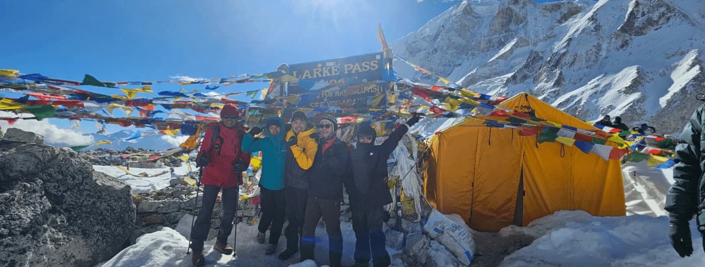
- The Larkya La Pass crossing itself. A single 9–10 hour day above 5,000 m, usually the coldest and most exposed section of the entire trek.
- Basic infrastructure. Fewer lodges, thinner food variety, and less reliable electricity than the Everest or Annapurna regions, simply because tourist volume here is intentionally kept low.
None of this requires mountaineering experience or technical climbing skills; no ropes, crampons for glacier travel, or ice axes are needed. But it does rule the trek out as a realistic first-time hiking destination for someone with zero prior multi-day trekking background. If you've completed at least one week-long trek at altitude before, or you're willing to train seriously for several months, the Manaslu Circuit is very achievable.
Manaslu Circuit Trek Distance
The full Manaslu Circuit Trek distance is approximately 177 km (110 miles), running from Soti Khola (or Machha Khola) in the south to Dharapani or Besisahar in the north, where the route joins the Annapurna Circuit trail. For comparison, that's slightly shorter than the Annapurna Circuit's 180–210 km but covers steeper, less-developed terrain.
Trekkers cover this distance over 12–14 walking days (within an 18-day full itinerary that includes Kathmandu time and acclimatization). Average daily distances run 8–16 km, but walking time matters more than distance here; most days take 5 to 7 hours because of the terrain, not the km count. Trails alternate between river-hugging paths with suspension bridge crossings in the lower section, steep switchbacks through rhododendron and pine forest in the mid-hills, and exposed alpine terrain above Samdo where the trail is rockier and less shaded.
For context, here's how the daily distance and walking time typically break down across the trek:
| Trail Section |
Approx. Distance |
Typical Walking Time |
| Soti Khola → Machha Khola |
14–16 km |
6–7 hours |
| Machha Khola → Jagat |
20–22 km |
6–7 hours |
| Jagat → Namrung (via Pewa) |
24–26 km |
11–13 hours (over 2 days) |
| Namrung → Sama Gaun (via Lho) |
18–20 km |
8–9 hours (over 2 days) |
| Sama Gaun → Dharamsala (via Samdo) |
16–18 km |
8–10 hours (over 3 days, with 1 rest day) |
| Dharamsala → Bhimtang (Larkya La crossing) |
20–22 km |
9–10 hours |
| Bhimtang → Dharapani |
24–26 km |
12–13 hours (over 2 days) |
The takeaway: no single day covers an extreme distance, but the cumulative distance without a real rest town, combined with rising altitude, is what makes the trek demanding rather than any one especially long stage.
Altitude of Manaslu Circuit Trek
Altitude is the single biggest factor behind Manaslu Circuit Trek difficulty. The trek starts around 700 m at Soti Khola and tops out at 5,106 m at Larkya La Pass, the highest point of the route.
| Location |
Altitude |
| Soti Khola (start) |
700 m |
| Jagat |
1,340 m |
| Namrung |
2,630 m |
| Lho Gaun |
2,956 m |
| Sama Gaun |
3,540 m |
| Samdo |
3,865 m |
| Dharamsala (Larke Phedi) |
4,460 m |
| Larkya La Pass (highest point) |
5,106 m |
| Bhimtang (after the pass) |
3,590 m |
| Dharapani (end) |
1,860 m |
Altitude sickness becomes a real risk above 3,500 m, which is why the standard itinerary builds in two acclimatization days, one at Sama Gaun (with an optional side hike to Pungyen Gompa or Manaslu Base Camp) and one at Samdo (with a side trip toward the Tibet border). Both rest days include a short uphill hike rather than full rest, following the "climb high, sleep low" principle that helps the body produce more red blood cells before the final push over the pass.
Common symptoms of altitude sickness to watch for include persistent headache, dizziness, loss of appetite, nausea, disturbed sleep, and shortness of breath at rest. Mild symptoms are common and usually resolve with rest, hydration, and slower pacing. Worsening symptoms, confusion, difficulty walking in a straight line, or breathlessness even at rest are a sign to descend immediately rather than push on toward the pass. For a deeper look at symptoms, prevention, and when to consider Diamox or evacuation, see our guide on altitude sickness in the mountains of Nepal.
Manaslu Circuit Trek Itinerary and Why It Affects Difficulty
The Manaslu Circuit Trek itinerary you choose changes how difficult the trek feels. Overland Trek Nepal runs an 18-day Manaslu Circuit Trekking itinerary built around two acclimatization days, which is the safer option for most trekkers. A 14-day Manaslu Circuit Trek via Larke La Pass is also available for experienced trekkers who want a faster pace with less buffer time.
Condensed 18-day structure:
- Days 1–2: Arrival and trek preparation in Kathmandu
- Days 3–9: Drive to Soti Khola, then trek through Machha Khola, Jagat, Namrung, and Lho Gaun to Sama Gaun (700 m → 3,540 m)
- Day 10: Acclimatization day at Sama Gaun, with an optional hike to Pungyen Gompa or Manaslu Base Camp
- Days 11–12: Trek to Samdo, with a second acclimatization day and side trip toward the Tibet border
- Day 13: Trek to Dharamsala (Larke Phedi), the final stop before the pass
- Day 14: Cross Larkya La Pass (5,106 m) and descend to Bhimtang — the hardest single day of the trek, at 9–10 hours
- Days 15–16: Descend through Tilije to Dharapani, then drive to Besisahar
- Days 17–18: Drive back to Kathmandu and departure
Shortening this itinerary (as some budget packages do) removes acclimatization buffer, which raises the real difficulty and altitude sickness risk even though the trail itself doesn't change.
Full 18-Day Manaslu Circuit Trek Itinerary (Day by Day)
| Day |
Route |
Max Altitude |
| 1 |
Arrival in Kathmandu |
1,400 m |
| 2 |
Trek preparation and permit processing in Kathmandu |
1,400 m |
| 3 |
Drive Kathmandu → Soti Khola |
700 m |
| 4 |
Trek Soti Khola → Machha Khola |
930 m |
| 5 |
Trek Machha Khola → Jagat |
1,340 m |
| 6 |
Trek Jagat → Pewa Village |
1,600 m |
| 7 |
Trek Pewa → Namrung |
2,630 m |
| 8 |
Trek Namrung → Lho Gaun |
2,956 m |
| 9 |
Trek Lho Gaun → Sama Gaun |
3,540 m |
| 10 |
Acclimatization day at Sama Gaun (optional Pungyen Gompa or Manaslu Base Camp hike) |
3,540 m |
| 11 |
Trek Sama Gaun → Samdo |
3,865 m |
| 12 |
Acclimatization day at Samdo (optional Tibet border viewpoint hike) |
4,998 m |
| 13 |
Trek Samdo → Dharamsala (Larke Phedi) |
4,460 m |
| 14 |
Cross Larkya La Pass (5,106 m), descend to Bhimtang |
5,106 m |
| 15 |
Trek Bhimtang → Tilije |
2,300 m |
| 16 |
Trek Tilije → Dharapani, drive to Besisahar |
760 m |
| 17 |
Drive Besisahar → Kathmandu |
1,400 m |
| 18 |
Final departure |
- |
This structure front-loads the altitude gain gradually through the first nine days, then uses the two rest days at Sama Gaun and Samdo as a buffer before the hardest single stretch of the trip, the Day 14 pass crossing.
What Makes Manaslu Circuit Trekking Difficult
Consecutive high-altitude days without a rest town
Unlike Everest Base Camp, which has Namche Bazaar as a built-up acclimatization hub, the Manaslu Circuit has smaller villages with basic teahouses and no large town to recover in past Sama Gaun.
Long, isolated approach
Reaching the trailhead itself involves 7–8 hours on an off-road highway from Kathmandu to Soti Khola. Once on the trail, help and evacuation points are sparser than on Everest or Annapurna routes.
Larkya La Pass crossing day
At 9–10 hours, starting before sunrise, crossing a 5,106 m pass in thin air is the physical and mental crux of the trip. Weather at the pass is unpredictable even in the trekking seasons.
Limited food and accommodation
Teahouses along the route are simpler than on Everest or Annapurna, with fewer attached bathrooms, less reliable electricity, and a smaller food menu — daal bhat, noodles, and basic Tibetan bread rather than the wider menus found on busier trails.
Weather swings by season
Spring and autumn offer the most stable weather. Winter brings temperatures below -20°C at the pass, and monsoon season adds landslide and flooding risk on the lower trail; see our full best season to visit Nepal guide for month-by-month conditions.
Month-by-Month Difficulty Breakdown
| Month |
Conditions |
Effect on Difficulty |
| March–April |
Rhododendrons blooming, mild days, cold nights above 3,500 m |
Favorable, one of the two best windows |
| May |
Warmer, hazier skies as pre-monsoon builds |
Good, slightly reduced visibility at altitude |
| June–August (Monsoon) |
Heavy rain, leeches on lower trail, landslide risk near river crossings |
Difficulty increases, trail conditions worsen, views reduced |
| September–October |
Clear post-monsoon skies, stable temperatures |
Favorable, the most popular and generally easiest window |
| November |
Cold, very clear, fewer trekkers |
Good, but nights at altitude drop sharply |
| December–February (Winter) |
Larkya La can be icy or snow-blocked, temperatures below -20°C at the pass |
Difficulty increases significantly, technical footing and cold exposure risk |
Manaslu Circuit Trek Difficulty vs. Everest Base Camp vs. Annapurna Circuit
| Feature |
Manaslu Circuit |
Everest Base Camp |
Annapurna Circuit |
| Distance |
~177 km |
~130 km |
~180–210 km |
| Highest point |
5,106 m (Larkya La) |
5,364 m (EBC) |
5,416 m (Thorong La) |
| Guide required |
Yes, mandatory by law |
Recommended, not required |
Recommended, not required |
| Rescue access |
Limited, remote |
Good (Namche, Lukla) |
Good (Manang, Muktinath) |
| Crowd level |
Low |
High |
High |
| Overall difficulty |
Strenuous |
Moderate to Challenging |
Moderate to Challenging |
Manaslu's altitude is technically lower than Everest Base Camp's, but the combination of a mandatory long trekking chain without a major rest hub, a remote restricted-area setting, and a long single pass-crossing day makes it feel harder for most trekkers, which is why guides often rank it as similarly or more demanding despite the lower peak elevation.
How Fit Do You Need to Be for the Manaslu Circuit?
You don't need mountaineering skills, but you do need to walk 5–7 hours a day on uneven terrain for close to two weeks straight. Difficulty also varies noticeably by trekker profile:
- Fit beginners with 2–3 months of dedicated training can complete the 18-day itinerary comfortably, provided they respect the acclimatization days and pace themselves.
- Trekkers who've already done Everest Base Camp, Annapurna Circuit, or a similar altitude trek generally find Manaslu manageable and often prefer it precisely because it's quieter.
- Very inexperienced hikers with no prior multi-day trekking should build up on a shorter Himalayan trek first, since Manaslu's remoteness leaves less margin for a rough first experience at altitude.
A Sample 10-Week Training Plan
- Weeks 1–3: Build a cardio base — brisk walking, hiking, or stair climbing 3–4 times a week, 45–60 minutes each session.
- Weeks 4–6: Add a weighted daypack (6–8 kg) to your hikes and introduce two strength sessions a week focused on legs, core, and back.
- Weeks 7–8: Increase to one long hike per week (4–6 hours) with a loaded pack, ideally on hilly or uneven terrain.
- Weeks 9–10: Taper intensity but keep frequency, shorter sessions, more rest, and make sure gear (boots especially) is fully broken in.
We recommend:
- 8–12 weeks of training before departure, mixing cardio, strength training, and hiking with a loaded pack
- At least one or two multi-day hikes beforehand if this is your first high-altitude trek
- A general health check with your doctor, particularly for anyone with heart or lung conditions
How to Reduce Manaslu Circuit Trek Difficulty
- Choose spring or autumn. These seasons offer the most stable weather for the Larkya La Pass crossing.
- Pick the 18-day itinerary over the 14-day one if you're a first-time high-altitude trekker; the extra acclimatization days matter more than the extra cost.
- Train specifically for consecutive walking days, not just single long hikes.
- Hire an experienced local guide and porter. Our guides have crossed Larkya La more than 20 times and know how to pace the group for the conditions on any given day.
- Pack for the pass, not just the valley see our Manaslu Circuit Trek packing list for what you actually need above 4,000 m.
- Get travel insurance with high-altitude rescue coverage before you fly to Nepal.
Permits Required (Because of the Difficulty Classification)
Because the Manaslu Circuit runs through a restricted area, three permits are mandatory, arranged only through a licensed agency:
- Restricted Area Permit (RAP): roughly $100/week in September–November, $75/week December–August. As of March 22, 2026, this can now be issued to a solo foreign trekker; the old two-person minimum no longer applies.
- Manaslu Conservation Area Permit (MCAP): issued via NTNC's ePermit system
- Annapurna Conservation Area Permit (ACAP): required near Dharapani, where the route crosses into the Annapurna Conservation Area
A licensed guide from a registered agency remains mandatory for every trekker on this route regardless of group size; this is a safety requirement, not just a paperwork formality, given how remote sections of the trail are. This permit system is part of why the trail stays quiet and well-preserved compared to Everest or Annapurna. Learn more about the region on NTNC's Manaslu Conservation Area project page.
Guides, Porters, Food and Accommodation on the Trail
A big part of managing Manaslu Circuit Trek difficulty comes down to the support team and infrastructure around you, not just your own fitness.
Guides and porters. Government-licensed guides who've crossed Larkya La Pass repeatedly know how to read the weather window, adjust pace for the group's slowest member, and recognize early altitude sickness symptoms before they become dangerous. Porters typically carry up to 20 kg (about 10 kg per trekker in a shared arrangement), which meaningfully reduces physical strain on the harder uphill stretches.
Accommodation. Teahouses along the route offer twin-share rooms with basic mattresses and blankets, and shared bathrooms are the norm, attached bathrooms are rare above Namrung. Above Samdo, expect very basic facilities with limited hot water and inconsistent electricity, usually available for a small per-device charging fee.
Food. Meals lean heavily on daal bhat (rice, lentils, and vegetables), noodle dishes, potato-based meals, soup, and Tibetan bread, with fresh vegetables becoming less available the higher you climb. Guides generally recommend avoiding meat above Sama Gaun, since it's carried up from lower elevations and doesn't stay fresh. Staying well-fed and hydrated is one of the simplest, most effective ways to reduce fatigue and altitude sickness risk on the trek.
A Note from Overland Trek Nepal
The Manaslu Circuit is genuinely one of the more demanding treks we run, but it's also one of the most rewarding: fewer crowds, real Tibetan culture, and views of Manaslu, Himlung Himal, and Annapurna II from Larkya La Pass that few trekkers ever see. Our guides have led this route for years and know exactly how to pace acclimatization for different fitness levels.
If you're weighing the Manaslu Circuit against Everest Base Camp or the Manaslu Base Camp Hike, reach out to our travel experts on WhatsApp at +977 9851138871, and we'll help you pick the right fit.

.webp&w=1200&q=75&dpl=dpl_EUd5Wwb28cTzwN6qQNwTKfhuRohE)
.webp&w=1200&q=75&dpl=dpl_EUd5Wwb28cTzwN6qQNwTKfhuRohE)