Boarding on the Manaslu Circuit Trek is like stepping into a living tapestry of Nepal's diverse landscapes and rich cultures. This less-traveled path offers an authentic adventure, winding through lush forests, terraced fields, and traditional villages that echo Tibetan influences. The journey climbs up to the formidable Larkya La Pass, at 5,106 meters, rewarding trekkers with panoramic vistas of the majestic Himalayas. To navigate this remote and intricate trail confidently, a detailed Manaslu Circuit Trek map becomes your trusted companion. It not only highlights key landmarks and elevation changes but also unveils hidden gems like the serene Birendra Lake and the culturally rich Tsum Valley. Armed with this map, you're set to fully immerse yourself in the unparalleled beauty and heritage of the Manaslu region.
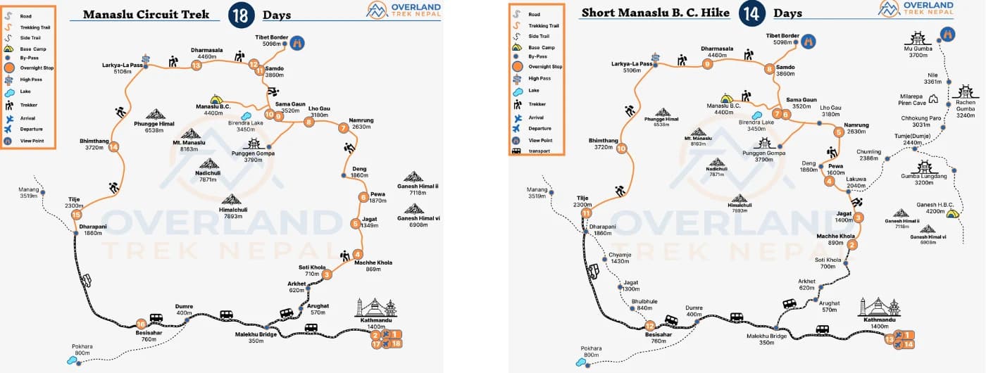
Manaslu Circuit Trek Map

Everything you need to know about the Manaslu Circuit Trek Route
The Manaslu Circuit Trek Map provides you with guidelines for the entire Manaslu Trek route, starting from Soti Khola and ending at Besisahar. The route map during the trek is very essential, especially if you are trekking in a restricted region like Manaslu. Trekking to Manaslu itself is a thrilling journey in the restricted region that goes through the rough terrain, landscapes, and forests, and takes you close to the 8th Highest Mountain in the world, Mt. Manaslu (8163m).
The route map includes a trekking trail, landmarks, elevations, and other several features that help in navigating the pathway. These invaluable features play a crucial role in a successful journey around Manaslu. It helps in navigating the pathway and reaching your ultimate destination on time. Here is the General Map that follows the Manaslu Trekking Trail:
Kathmandu > Macchekhola > Jagat > Pewa > Namrung > LhoGaun > Samagaun > Samdo > Dharmashala > Larkya La Pass > Bhimthang > Tilije > Tal > Syange > Besisahar > Kathmandu.
This is the general guidance of the Map that follows during the trek. If you start the trek from Kathmandu, depending on the itinerary and duration, it finishes at Besisahar within 14-18 days. However, if you add the Tsum Valley Trek with Manaslu, the route map can go up to 20-22 days.
Why you should carry the Manaslu Circuit Trekking Map with you?
The trekking route map plays an important role for the trekkers to track the trail and plan for the next destination. The following are the reasons why you should have a map during the Manaslu Trek:
- Navigating the Pathway: The journey during the entire trip goes through the remote landscapes of the region. Hence, trekkers should know the route and the next stop. The map helps in tracking the route clearly.
- Provides Elevation details: The Maximum elevation of this trek is 5106 meters at Larkya La Pass. Hence, the map provides you with awareness about the elevation gain and loss.
- Helps in Emergencies: In case of any emergencies, a map can help you in providing your information to the rescue team. Also, the rescue team can easily find you with the help of the map.
- Itinerary planning: Trekkers can modify their itinerary along the way if needed with the help of the map. With the estimated distance and duration, it gives flexibility to change the itinerary.
18-Day Manaslu Circuit Trek Route Map Itinerary

Day 01: Arrival in Kathmandu (1400meters)
Day 02: Trek Preparation
Day 03: Drive from Kathmandu to Sotikhola (700m, 7-8 hours)
Day 04: Trek from Sotikhola to Macchekhola (930m, 5-6 hours)
Day 05: Trek from Macchekhola to Jagat (1340m, 7-8 hours)
Day 06: Trek from Jagat to Pewa (1600m, 6-7 hours)
Day 07: Trek from Pewa to Namrung (2630m, 6-7 hours)
Day 08: Trek from Namrung to Lho Gaun (2956m, 4-5 hours)
Day 09: Trek from Lho Gaun to Sama Gaun (3540m, 4-5 hours)
Day 10: Acclimatization at Samagaun, Hike Manaslu Base Camp, or Pungyen Gompa
Day 11: Trek from Sama Gaun to Samdo (3865m, 4-5 hours)
Day 12: Acclimatization at Samdo. Side trip to Tibetan Border.
Day 13: Trek from Samdo to Dharamshala (44600m, 4-5 hours)
Day 14: Trek from Dharmashala to Bhimthang via Larkya La Pass (5106m, 8-10 hours)
Day 15: Trek from Bhimthang to Tilije (2300m, 5-6 hours)
Day 16: Trek from Tilije to Dharapani and Besi Sahar (760m, 7-8 hours)
Day 17: Drive from Besi Sahar to Kathmandu (1400m, 6-7 hours)
Day 18: Departure.
Short Manaslu Base Camp Hike Route Map & Itinerary

Day 01: Arrival in Kathmandu (1400m)
Day 02: Drive from Kathmandu to Macchekhola (930m, 8-10 hours)
Day 03: Trek from Macchekhola to Jagat (1340m, 6-7 hours)
Day 04: Trek from Jagat to Pewa (1600m, 6-7 hours)
Day 05: Trek from Pewa to Namrung (2660m, 6-7 hours)
Day 06: Trek from Namrung to Samagaun (3540m, 6-7 hours)
Day 07: Acclimatization at Samagaun and Hike to Manaslu Base Camp
Day 08: Trek from Sama Gaun to Samdo (3865m, 4-5 hours)
Day 09: Trek from Samdo to Dharamshala (4460m, 4-5 hours)
Day 10: Trek from Dharamshala to Bhimthang via Larkya La Pass (5106m, 8-10 hours)
Day 11: Trek from Bhimthang to Tilije (2300m, 5-6 hours)
Day 12: Drive from Tilije to Besisahar by Jeep (760m, 4-5 hours)
Day 13: Drive from Besisahar to Kathmandu (1400m, 7-8 hours)
Day 14: Departure
Manaslu Tsum Valley Trek Route Map and Itinerary

Day 01: Drive from Kathmandu to Macchekhola via Sotikhola (930m, 8-10 hours)
Day 02: Trek from Macchekhola to Jagat (1340m, 5-6 hours)
Day 03: Trek from Jagat to Lokpa (2240m, 6-7 hours)
Day 04: Trek from Lokpa to Chumling (2386m, 4-5 hours)
Day 05: Trek from Chumling to Chekampar (3031m, 5-6 hours)
Day 06: Trek from Chekampar to Nile (3361m, 4-5 hours)
Day 07: Hike to Mu Gumpa (3700m, 5-6 hours)
Day 08: Trek from Nile to Chekampar (3031m, 4-5 hours)
Day 09: Trek from Chekampar to Chumling (2386m, 5-6 hours)
Day 10: Trek from Chumling to Deng (1860m, 5-6 hours)
Day 11: Trek from Deng to Namrung (2630m, 5-6 hours)
Day 12: Trek from Namrung to Lho (2900m, 4-5 hours)
Day 13: Trek from Lho to Sama Gaun (3530m, 4-5 hours)
Day 14: Hike Manaslu Base Camp or Pungyen Monastery as an Acclimatization
Day 15: Trek from Sama Gaun to Samdo (3865m, 3-4 hours)
Day 16: Hike to the Tibetan Border as a part of Acclimatization
Day 17: Trek from Samdo to Dharamshala (4460m, 4-5 hours)
Day 18: Trek from Dharamshala to Bhimthang via Larkya La Pass (5106m, 8-10 hours)
Day 19: Trek from Bhimthang to Dharapani (1970m, 7-8 hours)
Day 20: Drive from Dharapani to Kathmandu (1400m, 8-10 hours)
The starting point of the Manaslu Circuit Trek
Often, the Manaslu Trek begins from Macchekhola. To reach Macchekhola, you must drive from Kathmandu by local bus or private Jeep. It takes around 8-10 hours. The distance from Kathmandu to Macchekhola is around 145 KM. Driving by local bus gives your local experience and adventure at the same time. However, by private jeep, provides more comfort and time-saving. After arriving at Macchekhola the trek begins and follows the route.
Where does Manaslu Circuit Trek end?
After crossing the adventurous Larkya La Pass at 5106 meters, the journey ends at Dharapani, which is also a part of the Annapurna Circuit Trek route. From Dharapani, you are most likely to take a Jeep to Besisahar or even hire a private Jeep and drive back to Kathmandu directly.
Detailed Pathway of the Manaslu Circuit Trek Map
Starting from Kathmandu to Macchekhola, the route follows several stoppages which have several trekking highlights and features.
- Kathmandu to Macchekhola: A long and scenic drive through several local villages, hillsides, and landscapes to reach the trailhead.
- Macchekhola to Jagat: The highlights of this route are; that it passes through several villages, terraced farmlands, and dense forests.
- Jagat to Deng: The route from Jagat to Deng generally passes through several traditional villages displaying the local lifestyle.
- Deng to Namrung: Enters the Manaslu Conservation Area. Opportunity to see the endangered Himalayan wildlife.
- Namrung to Samagaun: Starts the Tibetan-influenced villages and local people along with the changes in landscapes and mountain views.
- Samagaun to Larkya La Pass: Hike to Manaslu Base Camp or Birendra Tal. Follows the challenging Larkya La Pass Trek at 5106 meters with stunning views of the Himalayas.
- Bhimthang to Dharapani: The final leg of the trekking that connects the Annapurna Circuit Trek Route.
FAQs
How difficult is the route map of the Manaslu Circuit Trek?
The trekking route demands excellent dedication, determination, and physical fitness to complete the journey. The Pathway involves several terrains, diverse landscapes, high passes, and dense forests.
Why is the Manaslu Circuit Trek Map the most essential gear for hikers?
The Manaslu Circuit Trek Map is the most essential gear for trekkers to get enough information about the altitudes, distance, teahouses, and other several landmarks.
Is Macchekhola the starting point of Manaslu Trek?
Yes, Macchekhola is the starting point of the Manaslu Circuit Trek and Manaslu Base Camp Trek.
What is the total distance of the whole Manaslu Circuit Trekking?
The Manaslu Circuit Trek is approximately 180 KM from the starting to the ending point of the trek excluding transportation and side trips.
Planning your next adventure to Manaslu?
Overland Trek Nepal is a specialist and best trekking agency in Nepal for crafting Manaslu Circuit Trekking. With an experience of over a decade, we operate several Manaslu Tsum Valley Trekking packages in this region. Why you should plan your next trek with us?
- Professional guide who knows about the Manaslu region and is familiar with the trail, culture, tradition, and attractions.
- Hassle-free logistics and Manaslu Circuit Trek Permit management.
- Focus on safety measures while assisting in necessary rescue operations.
- Flexible Manaslu Trek Itinerary and affordable cost.
- Personalized and tailored trip with fixed departure.
- Complimentary services.
To get further information regarding the trek, feel free to contact us via email or WhatsApp at +9779851138871.
Best Trekking Company in NepalManaslu Base Camp TrekManaslu Circuit TrekNepal Travel BlogNepal Travel,Trekking CompanyNepal Trekking InformationTravel NepalTravel with Overland Trek Nerpal
Need Help? Call Us+977 9851138871orChat with us on WhatsApp
Latest Travel Blogs
.webp&w=1200&q=75&dpl=dpl_HaARamNQt5LmifUAHiMkUhwikbgZ)
.webp&w=1200&q=75&dpl=dpl_HaARamNQt5LmifUAHiMkUhwikbgZ)
Jul 27, 2026
By Anil
Is Everest Base Camp Trek Difficult? Complete 2026/27 Guide
Explore more.webp&w=1200&q=75&dpl=dpl_HaARamNQt5LmifUAHiMkUhwikbgZ)
Need Help? Call Us.+977 9851138871